For the sake of our community
Education, Preservation, and Recreation

Stephens County, Georgia

discover THE
hISTORIC
TUGALOO river CORRIDOR
A Project of the Stephens County Foundation

HISTORICAL SITES OF THE TUGALOO CORRIDOR
See and learn about our heritage by following the driving tour.
To enter the Tugaloo Corridor, from Toccoa travel east on US 123 for approximately 5 miles, turn left on Riverdale Rd. Go approximately 1/4 mile to Traveler's Rest to begin your tour.
click on pdf for a printable map and brochure


Stop 1. Traveler's Rest Historical Site
4339 Riverdale Rd/ Toccoa, GA -- phone: 706-356- 4362
OPEN TO THE PUBLIC/ Paid Admission
One of the first land grants following the American Revolution was made to Major Jesse Walton in 1784, and the first structure on the Traveler’s Rest site was his homestead, built in that year. In 1789, Major Walton was ambushed by a party of Creek Indians, and died a few days later. His widow sold their homestead to her brother, who sold it to James Wyly around 1800. By 1825, Wyly had replaced the old Walton homestead with the southern end of the structure which is on the site today.
The homestead was used as a stagecoach inn as it was strategically located close to the Unicoi Turnpike, a busy highway over the Appalachian Mountains, Georgia's first interstate highway. In 1838, Devereaux Jarrett purchased the Traveler’s Rest Inn from Wyly and expanded its services by adding the northern end of the house, operating an inn, trading post and post office there.
The site was designated a state historical site when, in 1955, the inn and adjoining acerage were sold to the State of Georgia by the granddaughter of Devereaux Jarrett, Mary Jarrett White (who, it is said was the first woman in Georgia to vote).
The exterior of the inn can be visited any day during daylight hours. The interior is open to visitors on Saturdays and Sundays between 9 AM and 5 PM.
Before touring the home, be sure to watch the video for some additional insights about this historic property and the families who lived there.
More information about the Unicoi Turnpike
For more information visit the website: Traveler's Rest

Stop 2. Providence United Methodist Church & Cemetary
(circa 1800/1857)
3968 Riverdale Rd/ Toccoa, GA
When you leave Traveler’s Rest, turn right on Riverdale road, go approximately 1/4 mile to Providence Church, which is on your left.
Providence Church was first built by Devereaux Jarrett, owner of Traveler’s Rest, in 1800. Later, C.K. Jarrett , son of Devereaux, inherited the property and in 1850 sold the church site and surrounding grounds to the Methodist Conference for the sum of $1,000. In the year 1857 the Jarrett brothers, sons of Devereaux, built a new church on the site of the original.
In 1950, and with much reluctance amongst the church members, the 93 year old church was torn down and the present brick structure was built. Graves in the cemetery date back to the origins of the original church.

Stop 3. Jarrett / Hayes House
494 Old Riverdale Rd/ Toccoa, GA
This is a private home and only to be viewed from the roadway.
From Providence Church, go approximately 9/10 of a mile north along Riverdale Road, then turn right on Old Riverdale Road. After approximately ¼ mile, the house will be on your left.
The house was built between 1847 and 1853 by Robert Jarrett, son of Devereaux Jarrett. He and his wife Elizabeth Ramsay Jarrett were the first occupants. Over the years, the house has often been referred to as Liberty Lodge. In 1860, the land owned by Robert surrounding the home was being farmed with the aid of his 43 slaves. Robert died in about 1864. His wife Elizabeth kept the house and land intact until her death in 1880. After her death, the home and about 150 acres went to her son Devereaux and his wife, Julia McAllister Jarrett. Upon Julia’s death in 1949, Elizabeth Turnbull Hayes, granddaughter of Devereaux, and her husband Henry Butler Hayes, purchased the property, taking up residence there in 1951. Henry Hayes died in the mid-1980’s and Elizabeth followed him in 2014 at the age of 100. Today the house is owned by Robert Daniel Hayes, the youngest son of Henry and Elizabeth.

Stop 4. Prather House (Riverside)
5185 Prather's Bridge Rd/ Toccoa, GA
This is a private residence, to be viewed only from the roadway.
From the Jarrett/Hayes house, continue along Old Riverdale Road (1/2 mile) until it rejoins Riverdale Road. Turn right and continue on Riverdale Road until it dead-ends into Prather Bridge Road (approximately 2 miles). Turn right, go approximately 1 1/2 miles, RIVERSIDE will be on your left.
This beautiful twelve columned, Greek revival antebellum home was built about 1850 by the Prather family, and is still occupied by descendants of the builder. It was built with slave labor and timber from the plantation. It is a classic example of the most favored architectural style of the pre-Civil War era, and is notable for its boxed columns, low wrap-around porch, and small veranda with decorative balustrade overhanging the front main doors.
As was usual in those days, the kitchen was separate from the house. The smoke house still stands and is now used as a garage. The Prather family cemetery is at the right side of the house, about 15 yards from the porch. During the Civil War, Confederate General Robert Toombs, a close friend of the Prathers, took refuge at Riverside, hiding in a closet to escape capture by Union troops.
(Source: Kathryn Trogdon, History of Stephens County, GA)
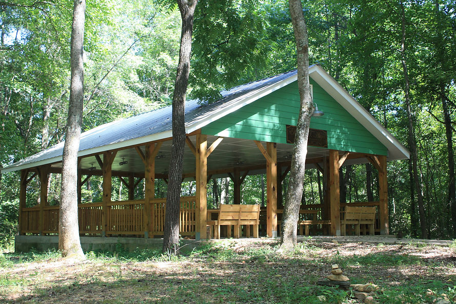


Stop 5. Tugaloo Bend Heritage Park
2104 Yonah Dam Rd. Toccoa, GA -- phone: 706-282-7636
OPEN TO THE PUBLIC
From the Prather House, stay left on to Yonah Dam Road, and travel about 2 miles. The Tugaloo Bend Heritage Park is on the right.
Tugaloo Bend is an 87 acre historic site which in the past has been the site of Estatoe, a native American village (Cherokee), then later the site of an operating farm for most of the 20th century.
The property is now owned and operated by The Stephens County Foundation, a community foundation which has created hiking trails, a picnic area, and a covered pavilion on the site, along with restroom facilities.
The area is open on Fridays from 1:30 PM to 5 PM, Saturdays from 8:30 AM until 5 PM, and Sunday afternoons from 1:30 PM until 5 PM. It can be made available at other times for groups when requested in advance.
For more information: visit: Tugaloo Bend General Information

Stop 6. Yonah Dam
From Tugaloo Bend, continue north for 2 miles up Yonah Dam Road to the dam.
The Georgia Power Company began construction on Yonah Dam in 1923, completing it in 1925. The Dam impounds Lake Yonah, a 325 acre lake with over 9 miles of shore line. Lake Yonah ( the word means “bear” in Cherokee), is the sixth in a chain of power company lakes built during that era for power generation for the area.
Below the dam begins a six mile stretch of the Tugaloo River, the only remaining unimpounded stretch of that river left in existence. (Note: The Dinky Line Railroad was constructed from a point on the Southern Railway near Toccoa out to the dam site for transportation of materials and equipment for construction. Upon completion of the dam, the Dinky Line Railroad was dismantled. One can still see the path of the rail line in numerous places along Yonah Dam Road, and can sometimes find the smaller railroad spikes along the route.)


Stop 7. Old Prather Bridge
From Yonah Dam, retrace your steps southward on Yonah Dam Road to the intersection in front of the Prather House (4.1 miles). Turn left. After about ½ mile, you will encounter the bridge over the Tugaloo River.
Look now, just south of the bridge are three pillars which once supported the Prather’s Bridge, a covered bridge which was constructed and destroyed four times during its history.
The bridge was first constructed in 1804 by James J. Prather. Prior crossings had to be made by ford or by ferry. The stone used for the pillars was cut from a quarry on the nearby Prather plantation, the timbers for the bridge also came from the plantation, with slave labor used in construction.
The first bridge was washed away, but replaced in 1850, only to be burned in 1863 during the Civil War.The bridge was replaced in 1868, and lasted until 1920 when it washed away again. It was rebuilt, only to be burned in 1978, and is yet to be replaced.

Stop 8. Cleveland Pike
The road you are on as you cross the bridge into South Carolina is Cleveland Pike.
Cleveland Pike is named for a hero of the American Revolution, Benjamin Cleveland. Cleveland was an Ensign, Lieutenant, Captain, and Colonel in the North Carolina Militia. Born in Prince William County VA, in 1738, Cleveland achieved great notoriety for his service as a militia Colonel in the Battle of King’s Mountain in 1780, considered to be the turning point in of the Revolution in the South. For his service, in 1793 he received a large land grant along the Tugaloo River. He died in 1806 at his home place along the South Carolina side of the river.

Stop 9. River Road/Lake Hartwell
After crossing into South Carolina on Cleveland Pike, take the first road to the right, River Road, continue along that road southward along the shores of Lake Hartwell (4 miles) Enjoy a leisurely ride taking the scenic water views of the lake. Be on the lookout for blue herons, eagles and other wild life.
Also be on the lookout for bicyclists who frequently ride along the road.
When you come to the stop sign turn right, back to US 123, crossing Lake Hartwell.
The next two points of interest (Broken Bridge and The Tugaloo Town Mound) can be seen as you are crossing over the bridge but for a better look, turn in to Stop 10- Stephens County Park on the left.


Stop 10. Broken Bridges/Stephens County Park
Stephens County Park, an area with picnic tables, a boat ramp, a restroom, and the locally famous BROKEN BRIDGES.
This bridge was originally a railroad bridge, built about 1870 and used until the new Trestle (which you traversed under on River road) was built in 1918 when the railroad was re-routed.
The removed section of the bridge has been relocated to Cobb Bridge Rd. in South Carolina and spans over Chauga Creek.


Stop 11. Tugaloo Town/ Tugaloo Mound
As you leave Stephens County Park, on the north side of US 123, you will see a historical marker describing Tugaloo Town, a dominant Cherokee village of the 1700's.
Colonel George Chicken, in his Journal of 1725, described Tugaloo Town as “the most ancient town in these parts”. He further describes the people of Tugaloo to be “the most turbulent in the nation and also the most taken notice of by the other towns”.
The name “Tugaloo” is derived from the Cherokee “DUGILU-YI”, describing the town located at the site you are seeing. The TUGALOO MOUND can be seen from the historical marker by looking north through the center span of the railroad trestle at a mound of trees in the center of the lake.
Prior to the Lake Hartwell impoundment in the late 1950’s, the Smithsonian Institution and the University of Georgia excavated the council house mound at Tugaloo Town in 1957-1958.